
The latest news of Indian Political Map will give you a brief overview of this country, includes all the states and union territories in the country with state capitals…
A Brief Overview of Indian Political Map 2019
The latest news of Indian Political Map will give you a brief overview of this country, includes all the states and union territories in the country with state capitals.
India, also known as the Republic of India is a country in South Asia.
This country is the seventh largest country by area and with more than 1.3 billion people, includes a total of 29 states along with seven union territories.
Not only it is the second most populous country but also is the largest democracy in the world.
Coastline of India measures 7.517 kilometers in length, out of which a distance of 5,423 kilometers belongs to the peninsular India and it shares a maritime border with Thailand and Indonesian 2,094 kilometers belonging to Andaman, Nicobar and Lakshadweep island chains.
Is it interesting to know that the Indian naval hydrographical charts along with mainland coastline include 43% sandy beaches, 46% mudflats or marshy shores and 11% rocky shores.
For more information, just need to read the Indian political map hereby.
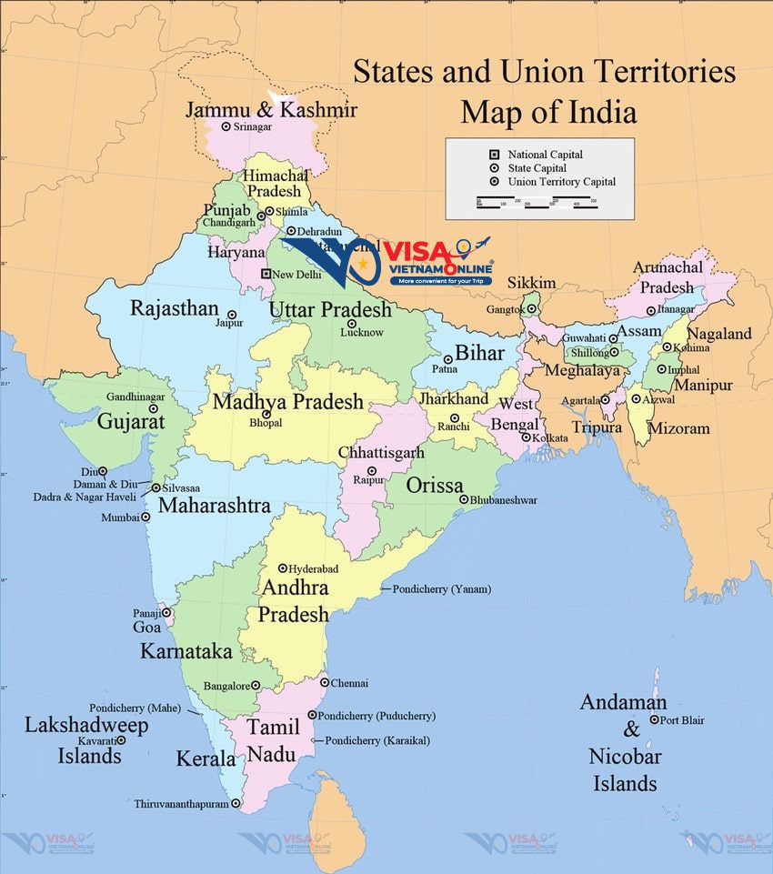
The Indian Political Map basically shows all the states and union territories in the country with state capitals. Here’s a brief overview of India.
|
Capital of India |
New Delhi |
|
Number of States in India |
29 |
|
Number of Union Territories in India |
7 |
|
Type of Government |
Federal Democratic Republic |
|
Geographic coordinates |
20 00 N, 77 00 E |
|
Land Area |
3,287,263 sq km |
|
Population |
1,326,801,576 |
|
Languages |
Hindi, English, Urdu, Tamil |
|
Literacy |
74.04% |
|
Total No. of Airports |
125 |
|
Total Railway Lines (total track length of network) |
115,000 km |
In detail, India is divided into six major zones: East India, West India, South India, North India, Northeast India and Central India.
Eastern India covers a total area of 418,323sq km, consists of the states of Bihar, Jharkhand, Orissa, West Bengal and a union territory Andaman and Nicobar Islands.
Citizens here speak English, Maithili, Nepali and Urdu. Bengali is the dominant language in the state of West Bengal whereas Odia and Hindi are the principal languages in the states of Orissa and Jharkhand respectively.
The Western region of India covers a total area of 508, 052sq km and has the financial capital of India – Mumbai.
Thanks to the capital city of Maharashtra, states of western India have a prosperous economy with relatively high standards of living.
Some of the popular states of western India can be listed are Gujarat, Goa and Maharashtra with the Union Territories of Daman and Diu and Dadra and Nagar Haveli.
Official languages of the states lying in Western India include Marathi, Gujarati, Konkani and English.
The North India has many populous cities such as New Delhi, Jaipur, Lucknow, Indore, Patna and Chandigarh, among them, Delhi is National Capital Territory. The economy of northern India is growing at a fast pace.
Over 19.31% of India’s total area is occupied by many states and union territories in Southern India as Tamil Nadu, Karnataka, Kerala, Andhra Pradesh, Telangana with the union territories of Lakshadweep and Puducherry.
Besides that, the capital of Karnataka, Bengaluru, is known as the “Silicon Valley of India” because it is the country’s leading exporter in IT sector.
Most populous cities of South India include Bengaluru, Hyderabad, Chennai, Coimbatore, Cochin and Mysore.
North East India includes Arunachal Pradesh, Assam, Meghalaya, Tripura, Mizoram, Manipur, Nagaland and the Himalayan state of Sikkim. There is great ethnic and religious diversity within the states.
The Central zone of India primarily refers to Madhya Pradesh and the newly formed state of Chhattisgarh.
UPDATE: On 2nd June 2014, Telangana split from Andhra Pradesh and become the newest 29th State of India with Hyderabad is the capital of the new state.
There are a total of 29 states and 7 Union Territories in India. What are their capital cities? We have made a refreshed and updated list of all the states below:
|
States (in alphabetical order) |
Capital City |
|
Andhra Pradesh |
Amravathi [*Hyderabad initially] |
|
Arunachal Pradesh |
Itanagar |
|
Assam |
Dispur |
|
Bihar |
Patna |
|
Chhattisgarh |
Raipur |
|
Goa |
Panaji |
|
Gujarat |
Gandhinagar |
|
Haryana |
Chandigarh (shared with Punjab) |
|
Himachal Pradesh |
Shimla |
|
Jammu & Kashmir |
Srinagar (Summer) Jammu (Winter) |
|
Jharkhand |
Ranchi |
|
Karnataka |
Bangalore |
|
Kerala |
Thiruvananthapuram |
|
Madhya Pradesh |
Bhopal |
|
Maharashtra |
Mumbai |
|
Manipur |
Imphal |
|
Meghalaya |
Shillong |
|
Mizoram |
Aizawl |
|
Nagaland |
Kohima |
|
Odisha (Orissa) |
Bhubaneshwar |
|
Punjab |
Chandigarh (shared with Haryana) |
|
Rajasthan |
Jaipur |
|
Sikkim |
Gangtok |
|
Tamil Nadu |
Chennai |
|
Telangana (from June 2, 2014) |
Hyderabad |
|
Tripura |
Agartala |
|
Uttar Pradesh |
Lucknow |
|
Uttarakhand |
Dehradun |
|
West Bengal |
Kolkata |
|
Union territory (in alphabetical order) |
Capital City |
|
Andaman and Nicobar Islands |
Port Blair |
|
Chandigarh |
Chandigarh |
|
Dadra and Nagar Haveli |
Silvassa |
|
Daman and Diu |
Daman |
|
Lakshadweep |
Kavaratti |
|
Delhi – National Capital Territory |
Delhi |
|
Puducherry (Pondicherry) |
Pondicherry |